
The true location of Castle Dracula
Over the last decade, Dracula experts have wondered where exactly Castle Dracula was supposed to be located. The descriptions in the novel are extremely vague: the characters travel there through snowstorms and Jonathan Harker, Professor Van Helsing and Mina all fall asleep while they approach the vampire's headquarters. Therefore, most authors have been content with the conclusion that the castle is in or somewhere near the Borgo Pass.
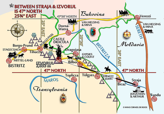
If we take a close look at the text, however, we learn that the Count's carriage with Jonathan Harker as its only passenger circles around in the Pass until midnight and then, while driving in the direction of Bukovina, makes a sharp turn to the right. It takes another four hours, more or less, before Jonathan arrives at the Castle Dracula. During this time, the Count's quick horses must already have brought him away from the Borgo Mountains. Instead, he must have entered the Călimani Mountains, the youngest region of the Carpathians. Millions of years ago, there was a huge volcano here. After it became inactive, the cone collapsed leaving a huge crater or caldera, ten kilometres in diameter.
A second clue about the Castle's location is that Mina, when she expects Jonathan to arrive from the East, sees the River Bistrița as it winds its way in curves through the landscape. To have a clear view of this stream, however, she must have a very high viewpoint. The only place, actually, from where she can look across the hills that separate Transylvania from Moldavia, is the eastern ridge of the mentioned caldera.
The third piece in the puzzle is the route of the Gypsies who take over the box with the Count from the Slovaks who are rowing up the River Bistrița towards the North. In his diary, Jonathan notes that he hopes to catch up with the Slovaks before they reach "Straba." Old maps of Moldavia teach us that only Straja near the town of Bicaz can be meant here. From here, the distance between the river and the border with Transylvania is shorter than from anywhere else on the course of the Bistrița. This matches another remark by Harker: he assumes that the Count's men would wage their cross-over to the Count's homeland around the 47th Parallel. Straja is just a few kilometres south of this degree. For the Count's men, it would be nonsense to row their boat all the way up the Bistrița to Vatra Dornei and only from there continue on horseback: instead of 110 km, the distance to be covered would be 220 km, twice as much. Much more plausible is that they would have entered Transylvania either through the Bicaz Pass or the Tulghe Pass, a bit farther north. From there, several roads lead to Bilbor, close to the ridge of the Călimani caldera.
From these three clues, I already had a pretty precise idea which of the mountain tops on the eastern side of the volcanic crater might have been the location of the Castle, Stoker had in mind—provided that he had a precise idea at all: the Rețițis, the Izvorul, or the Cserbükk. Reading through Bram Stoker's notes for Dracula again I found an obscure remark. It contained the coordinates of a point on the map between "Strasha" (Straja) and "Isvorol" or "Isvorul." As these coordinates turned out to point to a spot in the Arabian Desert: the novelist must have mixed up latitude and longitude. Stoker's first scribble was correct; the mistake was only introduced when he overwrote his text in pencil and finally fixed it in ink.
Drawing a straight line from Straja through the indicated point leads us to the mountain peak we already identified as "Izvorul"—during Stoker's time, both the spellings "Izvorul" and "Isvorul" were used. Of the three summits mentioned before, only the Izvorul was indicated on the map in the book by Charles Boner—one of Stoker's sources. To me, it seems evident that Stoker must have used a detailed map to plot the most efficient route for the Gypsies and made a note about the point where they might cross the border: after correction for latitude and longitude, the given coordinates (47° North, 25¾° East) are almost identical with those of Tulghe (Tölgyes).
Logically, the Izvorul must have been the place Bram Stoker had in mind for his fictitious Castle Dracula, like in the case of the Count's identity, he did not want to disclose this information to his readers: it might have been embarrassing if one of his critics would have climbed this very mountain top, only to see that it was completely emtpy...
READ MORE:
- "Castle Dracula – Its Exact Location reconstructed from Stoker’s Novel, his Research Notes and Contemporary Maps." Linkoeping University Electronic Press, Sweden. Published on 7 February 2012. PDF file available via http://ep.liu.se/ea/cis/2012/001/.
- "Dracula’s Truth Claim and its Consequences." Journal of Dracula Studies, ISSN 11492-708X. Volume 16 (2014), pages 53-80. Published in October 2014.
- "Count Dracula's Address and Life-Time identity." Chapter for the book Dracula—An International Perspective, edited by Marius Crișan, published by Palgrave Gothic/Springer in Nov. 2017.